
Ask price
diary maps - maps for agendas
<b>Political maps for school agendas and projects.</b>
<br><br>
Political Map of Spain (esp, cat, eus), Map of Països Catalans (cat), Political Map of Portugal (port), P
(...) Read more »
Adobe Illustrator, Acrobat PDF

95,00 €
Alicante - city map with postal codes
Digital street map of the city of Alacant/Alicante (Valencian Community) with the delineation of blocks of houses, singular buildings, hydrographic network, parks, green areas, railways, urban roads,
(...) Read more »
Adobe Illustrator, Acrobat PDF

65,00 €
Jumilla - city map
Digital street map of Jumilla (Region of Murcia) with the delineation of streets and squares, blocks of houses, parks and green areas with colours and names.
<br>
Tourist map of the urban area
(...) Read more »
Adobe Illustrator, Acrobat PDF

79,00 €
A Coruña (Corunna) - Map of province with parroquias and postal codes
Map of the province of A Coruña (Galicia, Spain) with regional and provincial boundaries, coloured municipalities, parish boundaries and all postcodes.
Adobe Illustrator, Acrobat PDF

45,00 €
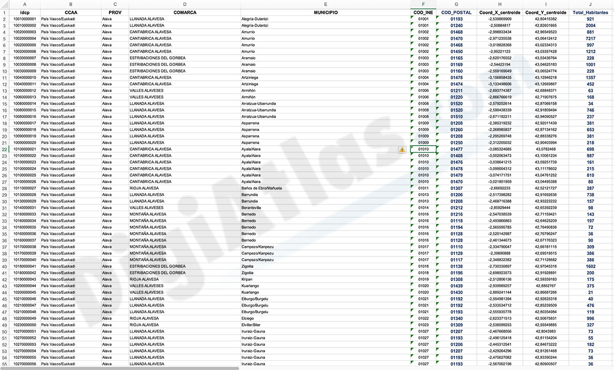
Santa Cruz de Tenerife- Population by postal code
<b>Population data by postcode for the province of Santa Cruz de Tenerife (Canary Islands)</b>.
<br><br>
An Excel file is downloaded with the following structure: idpc - Auto
(...) Read more »
Excel

350,00 €
Portugal - Population by 7-digit postal code
<b>Excel file with the inhabitants by 7-digit postcodes of Portugal</b>.
<br>
Demographic data for Portugal. Approximate population of each 7-digit postal code point in whole Portu
(...) Read more »
Excel
Ask price
Population by Postcode (Historical 2012-2022 biannual)
<b>-HISTORICAL POPULATION BY POSTCODE IN SPAIN.</b>
<br>
These are several digital files, in Excel format, with population data by postcode from 2012 to 2022, every two years.
<
(...) Read more »
Excel
98,00 €
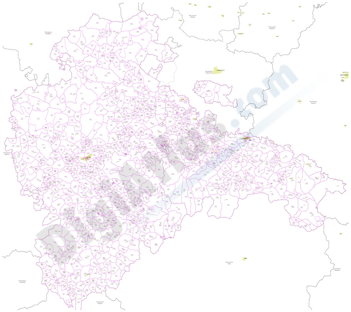
Burgos and La Rioja - inhabitants by postcode
Digital map of the <b>province of Burgos and the autonomous community of La Rioja</b> showing the municipalities, postcode boundaries and the <b>number of inhabitants of each postcod
(...) Read more »
Adobe Illustrator, Acrobat PDF y Excel
975,00 €
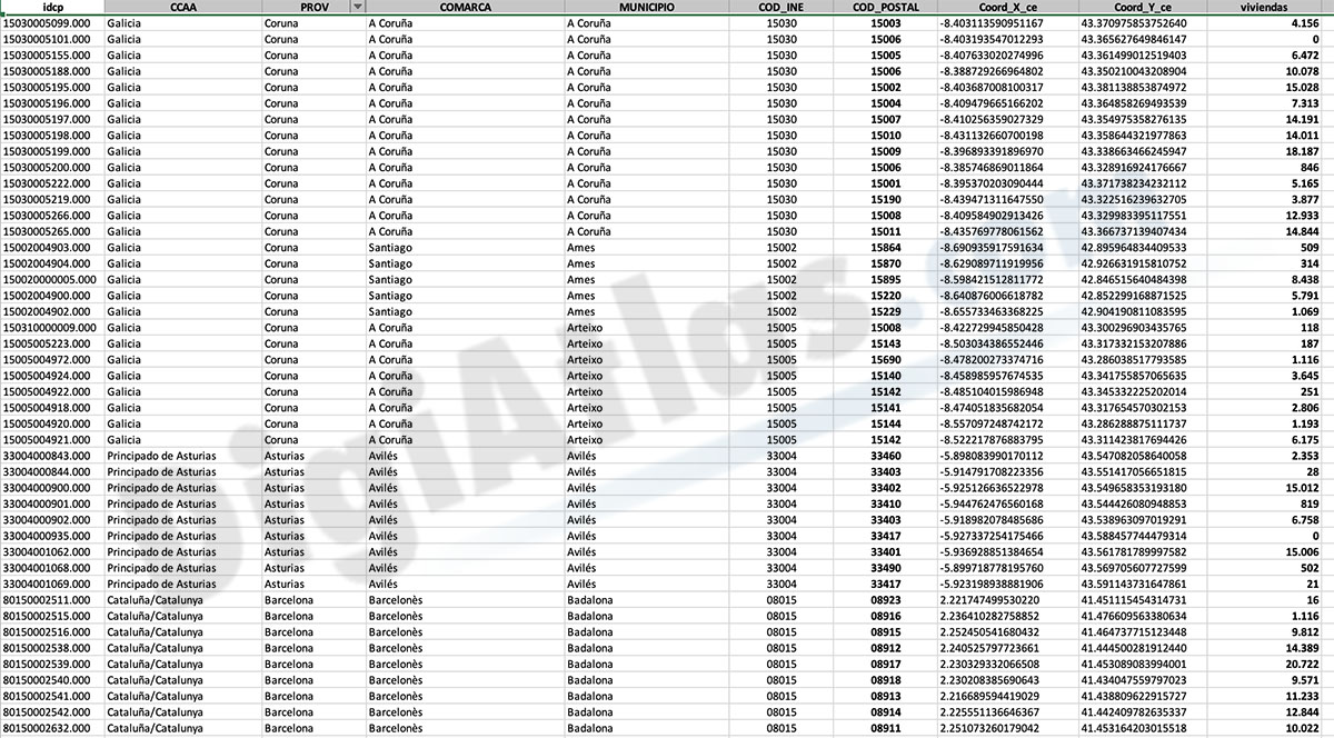
Number of dwellings by postcode in Spain
<b>Number of dwellings by Postal Code</b>
<br>
There are 235 municipalities in Spain with more than 25,000 inhabitants and with more than one postal code within their municipal bo
(...) Read more »
Excel

175,00 €
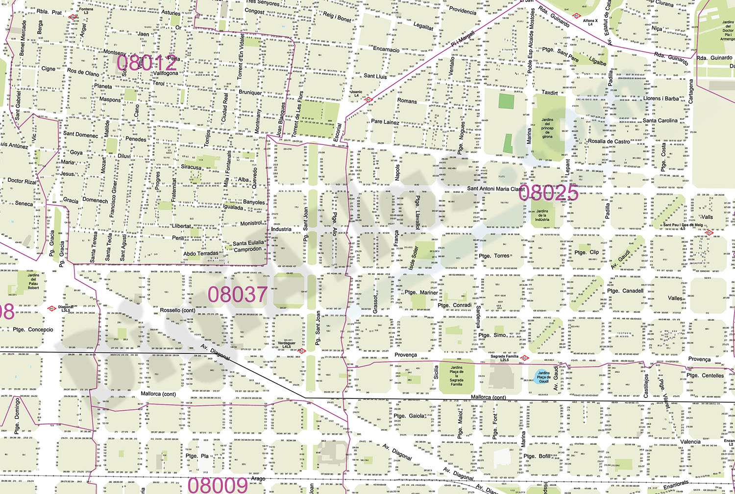
Barcelona - City map with portal numbers
Digital street map of Barcelona with street numbers.
<br>
The map shows the delineation of streets and squares, blocks of houses, parks, green areas, with colors and names of all streets and s
(...) Read more »
Acrobat PDF

75,00 €
Sarria district map
Digital map of the district of Sarrià (Barcelona)
Adibe Illustrator, Acrobat PDF

245,00 €
Map of Galicia and North Portugal
Vector map of the Autonomous Community of Galicia and Northern Portugal.
<br>
Digital map of the provinces of A Coruña, Lugo, Ourense and Pontevedra, together with the districts of Vian
(...) Read more »
Adobe Illustrator, Acrobat PDF

175,00 €
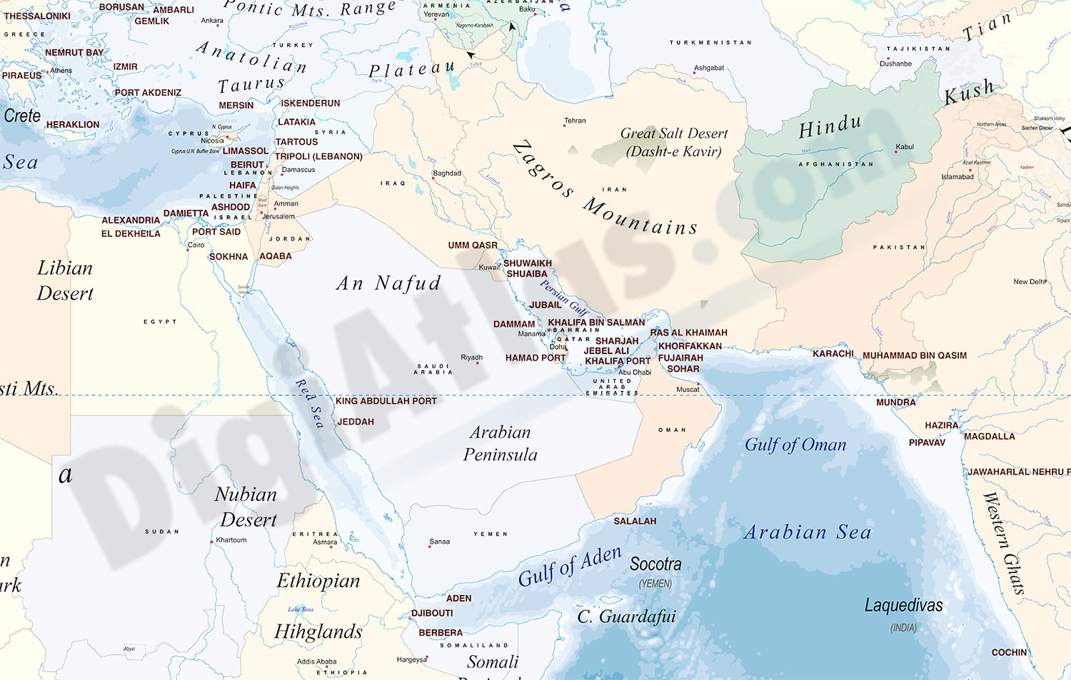
Physical-Political Worldmap with Container Ports
<b>Physical-political digital world mapa with container ports.</b>
<br>
The map shows coloured altimetry and bathymetry bands, country borders, capitals, major rivers and lakes, ge
(...) Read more »
Adobe Illustrator, Acrobat PDF

125,00 €
Portugal - Excel population by 4-digit postal code
<b>Excel file with the inhabitants by 4-digit postcode of Portugal.</b>
<br>
Demographic data of Portugal. Number of inhabitants per 4-digit postcode area of all Portugal (mainland
(...) Read more »
Excel

75,00 €
A Coruña - map Municipal District
<b>Digital street map of A Coruña</b> (Capital of the Province of A Coruña) with the delineation of the urban area, municipal limits and names of streets, squares and singula
(...) Read more »
Adobe Illustrator, Acrobat PDF
