
PACK DIGIATLAS
Download up to 15 digital maps of your choice through a subscription to the 'Pack DigiAtlas'.


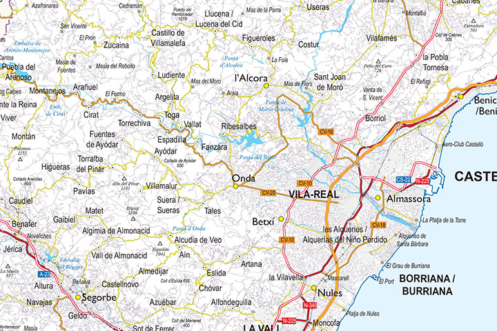
-Description:
Digital map of the province of Castellón (Valencian Community) at a scale of 1:325.000 and adjusted to a DIN A2 sheet.
The map shows the regional and provincial boundaries and municipalities, capitals, cities and towns grouped according to their number of inhabitants, network of motorways, dual carriageways, national and regional roads of first and second order, local roads, other roads, roads and tracks, AVE and conventional rail network, mountain passes, peaks, rivers and major lakes.
Two vector files are downloaded: one in Adobe Illustrator (.ai) format, 100% editable, which allows you to modify and customise colours, texts and styles. And a second version in Acrobat PDF format to print the map directly at the desired size, always with the maximum resolution.
The map includes the official denomination of the Valencian municipalities, a legend in Spanish and another in Valencian.
-Original measurements:
420x594 mm (DIN A2) (Fully resizable vector file for High-quality printing).
-Download formats:
Adobe Illustrator, Acrobat PDF
- This map is also available through the PACK DIGIATLAS »
-You can also request a quote » to modify this map and adapt it to your projects.
Download up to 15 digital maps of your choice through a subscription to the 'Pack DigiAtlas'.

Postcode maps of cities, regions and countries. Optionally with demographic data for geo-marketing projects.

City street maps with delineation of urban areas, streets, squares, parks, green areas, buildings of interest, etc.
DigiAtlas select every week until three random maps from their catalog and intends to offer them at a very lower price than its regular cost.
These maps change every 7 days. If either of them matches your interest take advantage of this opportunity to acquire digital maps to a very special price.