
55,00 €
Altea- city map
Street map of Altea city (province of Alicante, Valencian Community, Spain) in digital format. Map shows urban blocks of buildings, parks and green zones, street and square names. Fully editable vecto
(...) Read more »
Adobe Illustrator, Acrobat PDF

55,00 €
Amurrio & Ondategi - city maps
Vector-file map of Amurrio & Zigoitia (province of Alava, Spain). All features are in separated layers.
Adobe Illustrator, PDF

55,00 €
Antequera city map
Street map of Antequera city (province of Malaga, Andalucia, Spain). Map contains urban areas, green zones, street names and other cartographic features. Fully editable vectorized file organized on se
(...) Read more »
Adobe Illustrator, PDF

55,00 €
Argentona (Barcelona, Spain) - city map
Vector-file map of Argentona (Barcelona, Spain) city. All features are in separated layers. Street coordinates are included.
Adobe Illustrator, PDF

55,00 €
Avila - city map center
Digital street map of the city centre of Ávila (Autonomous Community of Castile and León - Spain), with the delineation of streets and squares, blocks of houses, parks and green areas, with colours
(...) Read more »
Adobe Illustrator, Acrobat PDF

55,00 €
Avilés city map
Vector-file map of Aviles (Asturias-Spain) city. All map features are in separated layers.
FreeHand, Illustrator, PDF

Ask price
Badajoz (Spain) - city map
Digital street map of Badajoz with the delineation of streets and squares, blocks of houses and green areas, with colours and names. All the elements are grouped in separate, fully editable layers.
Adobe Illustrator, Acrobat PDF

55,00 €
Badalona (Barcelona, Spain) - city map
Vector-file map of Badalona (Barcelona, Spain) city. All features are in separated layers. Street coordinates are included.
Adobe Illustrator, PDF

95,00 €
Barcelona - city map
Vector file map of Barcelona (Catalonia, Spain). Include subway lines and street name index. All features are in separated layers.
Adobe Illustrator, Acrobat PDF

175,00 €
Barcelona - City map with portal numbers
Digital street map of Barcelona with street numbers.
The map shows the delineation of streets and squares, blocks of houses, parks, green areas, with colors and names of all streets and squares. It also shows the postal codes and the numbering of the doorways of all the buildings.
A file is downloaded in Acrobat PDF vector format.
See less «
Acrobat PDF
175,00 €
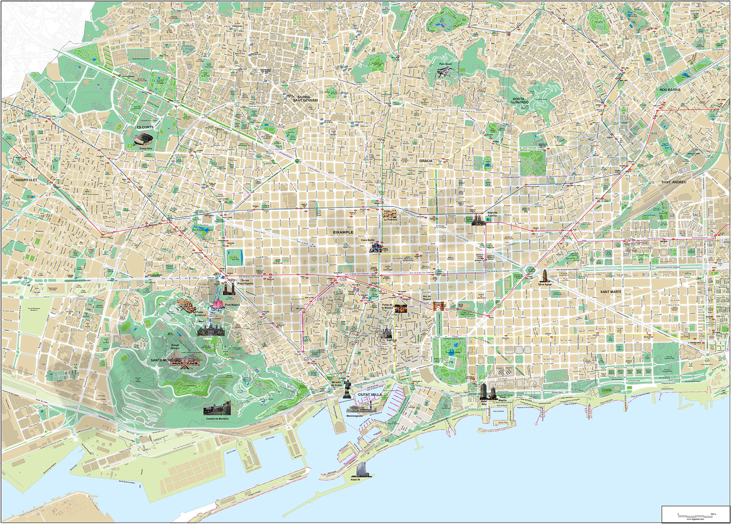
Barcelona - touristic city map
Touristic map of Barcelona (Spain), includes photos of main important places for tourists, and Metro (Underground) and FFCC (train) lines and stations.
(...) Read more »
Adobe Illustrator, Acrobat PDF

55,00 €
Barcelona City Center Street Map
Vector map of Barcelona center (Spain), showing streets, squares and green zones with their colours and names. Also included Metro (Underground) and FFCC (train) stations.
All map features are organi
(...) Read more »
Adobe Illustrator, Acrobat PDF

125,00 €
Barcelona City map
Digital street map of Barcelona with the delineation of streets and squares, blocks of houses, parks and green areas, with colours and names of all the streets.
(...) Read more »
Adobe Illustrator, Acrobat PDF

39,00 €
Barcelona city map (raster file)
Digital street map of Barcelona in poster size, with the delineation of streets and squares, blocks of houses and green areas, with colors and names. Includes metro and FFCC stations.
Imagen TIFF a 300 dpi de resolución

Ask price
Barcelona entire city map
Digital street map of all Barcelona with the delineation of streets and squares, blocks of houses and green areas, with colors and names.
(...) Read more »
Adobe Illustrator, Acrobat PDF

