
Ask price
Location maps
We provide accurate and personalized 'Location Maps', like "How to go...", to include in your webpage, reports, brochures invitation card, etc.
Adobe Illustrator, PDF

79,00 €
Madrid - detailed map of Community
Digital map of the Community of Madrid at a scale of 1:100,000 with the regional and provincial boundaries, municipalities and towns grouped according to their number of inhabitants, network of motorw
(...) Read more »
Adobe Illustrator, Acrobat PDF

59,00 €
Major roads map of Spain and Portugal
Digital map of Spain and Portugal with the general road network, hydrographic network and main towns.
(...) Read more »
Adobe Illustrator, Acrobat PDF

59,99 €
Mallorca - Map of Balearic Islands
Digital map of the Balearic Islands, including the entire Balearic archipelago: Mallorca, Menorca, Ibiza-Eivissa and Formentera. Tourist map at a scale of 1:300.000 with the main towns, road network,
(...) Read more »
Adobe Illustrator, Acrobat PDF

125,00 €
Mallorca island
Digital map of the island of Mallorca (Balearic Islands, Spain) at a scale of 1:150.000 (90 x 90 cm) with detailed geographical and tourist information.
(...) Read more »
Adobe Illustrator, Acrobat PDF + TIFF

59,99 €
Map of A Coruña (Corunna)
Digital map of the province of A Coruña (Galicia) at a scale of 1:200.000 with the autonomous, provincial and municipal limits (Concellos), capitals, cities and population centres organised ac
(...) Read more »
Adobe Illustrator, Acrobat PDF

19,95 €
Map of Afghanistan
Fully editable vector file map of the Islamic Republic of Afghanistan showing political layers of inner administrative division, their names and capitals.
Adobe Illustrator, Acrobat PDF

59,99 €
Map of Albacete
Digital map of the province of Albacete (Castilla-La Mancha) at a scale of 1:300.000 with the autonomous and provincial limits, municipalities and towns, motorways, dual carriageways, national and aut
(...) Read more »
Adobe Illustrator, Acrobat PDF

19,95 €
Map of Albania
Map of Albania showing their inner administrative division, with names and capitals. Fully editable vector file organized in separate layers.
Adobe Illustrator, PDF

Ask price
Map of Alboran
Map of Alboran Island with relief and bathymetry.
Relief map of the Iberian Peninsula and North Africa, centred on Alboran Island, with roads and towns.
(...) Read more »
Adobe Illustrator, Acrobat PDF, imagen TIFF

55,00 €
Map of Algarve (Portugal)
Map of the Algarve region (Portugal) with municipalities, roads and towns.
Digital file in 100% editable vector format, organized in separate layers.
Adobe Illustrator, Acrobat PDF

19,95 €
Map of Algeria
Digital political map of Algeria.
(...) Read more »
Adobe Illustrator, Acrobat PDF
19,95 €
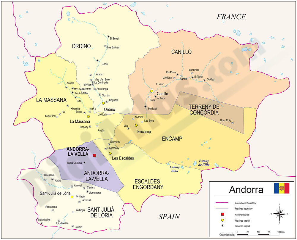
Map of Andorra
Digital map of Andorra in fully editable vectorized file. Map of the Principality of Andorra shows inner administrative political division, with their names and capitals. Map include major roads and a
(...) Read more »
Adobe Illustrator, PDF

19,95 €
Map of Angola
Fully editable vector file. Include political layers of inner administrative division, with their names and capitals.
Adobe Illustrator, PDF

79,00 €
Map of Antarctica
Fully editable vector file map of Antarctica. Colored lands and glaciers.
Adobe Illustrator, PDF, JPG (300dpi)

