
79,00 €
Map of Albacete, Valencia and Castellon provinces with municipalities and postal codes
Map of Albacete, Valencia and Castellon provinces showing municipalities and 5-digit postal code areas. Vectorized fully editable format.
Adobe Illustrator, PDF

69,00 €
Map of Alicante and Murcia provinces with municipalities and postal codes
Map of Alicante and Murcia provinces showing municipalities and 5-digit postal code areas. Vectorized fully editable format.
Adobe Illustrator, PDF

59,00 €
Map of Alicante province with municipalities and postal codes
Digital map of the province of Alicante (Valencian Community, Spain) showing municipality borders, capital, cities, towns and all 5-digit postal code areas.
(...) Read more »
Adobe Illustrator, Acrobat PDF

59,00 €
Map of Alicante with municipalities, major roads and postal codes
Map of province of Alicante (Valencian Community, Spain) showing municipalities, 5-digit postal codes areas and major roads. Continuously Updated.
Adobe Illustrator, PDF

59,00 €
Map of Almeria province with municipalities and postal codes
Digital map of the province of Almería (Andalucia, Spain) with postcodes, municipalities, capitals, cities and towns grouped according to the number of inhabitants.
(...) Read more »
Adobe Illustrator, Acrobat PDF

59,00 €
Map of Asturias autonomous community with municipalities and postal codes
Map of Principality of Asturias (autonomous community in north-west Spain) showing municipalities borders, capitals, cities and towns organized depending on population size and all 5-digits postal cod
(...) Read more »
Adobe Illustrator, Acrobat PDF

59,00 €
Map of Avila province with municipalities and postal codes
Map of Avila province (Castile and León - Spain) showing municipalities borders and 5-digits postal codes.
Adobe Illustrator, PDF, JPG(300 dpi)

59,00 €
Map of Badajoz province with municipalities and postal codes
Map of Badajoz province (Extremadura-Spain) showing municipalities borders and postal codes.
Adobe Illustrator, PDF, JPG(300 dpi)

59,00 €
Map of Balearic Islands with municipalities borders and postal codes
Digital map of the Balearic Islands Autonomous Community with municipalities, towns and all 5-digit postal codes.
100% editable vector files, updated to the current year.
(...) Read more »
Adobe Illustrator, Acrobat PDF

59,00 €
Map of Barcelona province with municipalities and postal codes
Digital map of the province of Barcelona with the limits of the municipalities, capitals, cities and towns grouped by number of inhabitants and all the postcode areas.
(...) Read more »
Adobe Illustrator, Acrobat PDF

59,00 €
Map of Bizkaia province with municipalities and postal codes
The Biscay Postal Code Digital Map.
(...) Read more »
Adobe Illustrator, Acrobat PDF

59,00 €
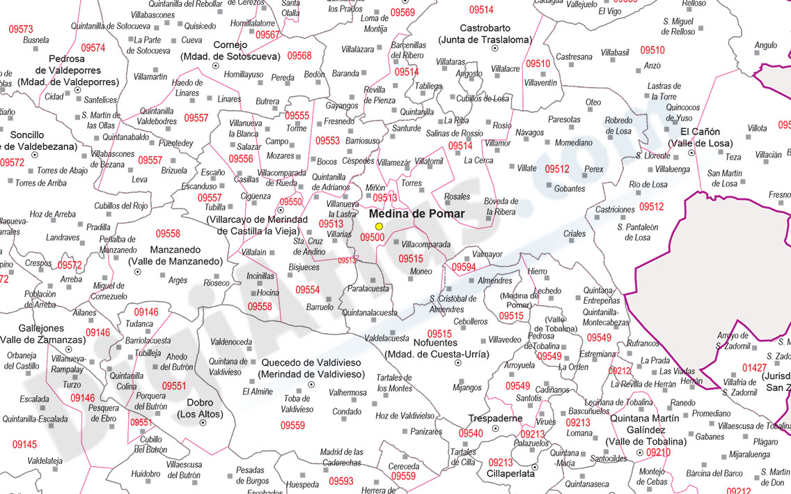
Map of Burgos province with municipalities and postal codes
Digital map of the province of Burgos (Castilla y León) with all the postcodes, municipalities, capitals, cities and towns grouped according to their number of inhabitants.
(...) Read more »
Adobe Illustrator, Acrobat PDF

59,00 €
Map of Caceres province with municipalities and postal codes
Digital map of the province of Cáceres (autonomous community of Extremadura, Spain) with municipalities, towns and all postcodes.
(...) Read more »
Adobe Illustrator, Acrobat PDF

59,00 €
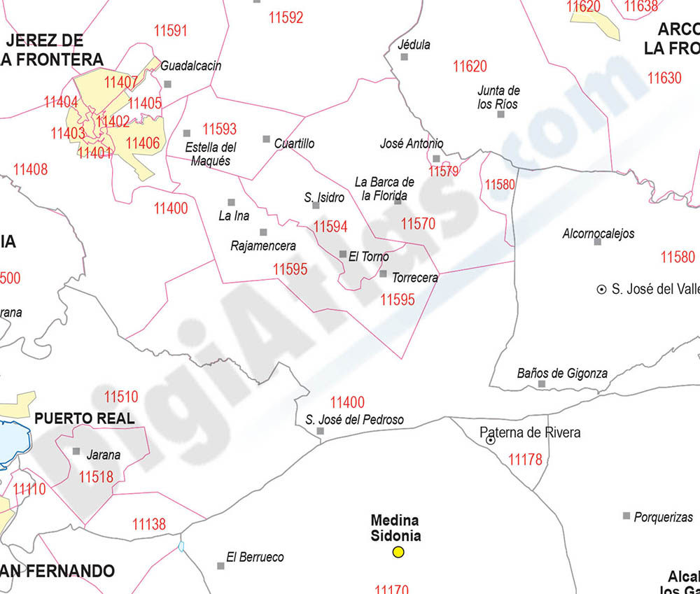
Map of Cadiz province with municipalities and postal codes
Map of Cadiz province (Andalucia-Spain) showing municipalities borders, cities and 5-digit postal code areas. Vectorized fully editable format. Continuously Updated.
Adobe Illustrator, PDF, JPG(300 dpi)

59,00 €
Map of Cantabria autonomous community with municipalities and postal codes
Map of Cantabria autonomous community (Spain) showing municipalities borders, towns, cities and 5-digits postal codes.
(...) Read more »
Adobe Illustrator, Acrobat PDF

