
120,00 €
Roadmap of Spain and Portugal
Digital map of roads and towns in Spain and Portugal.
(...) Read more »
Adobe Illustrator, Acrobat PDF

Ask price
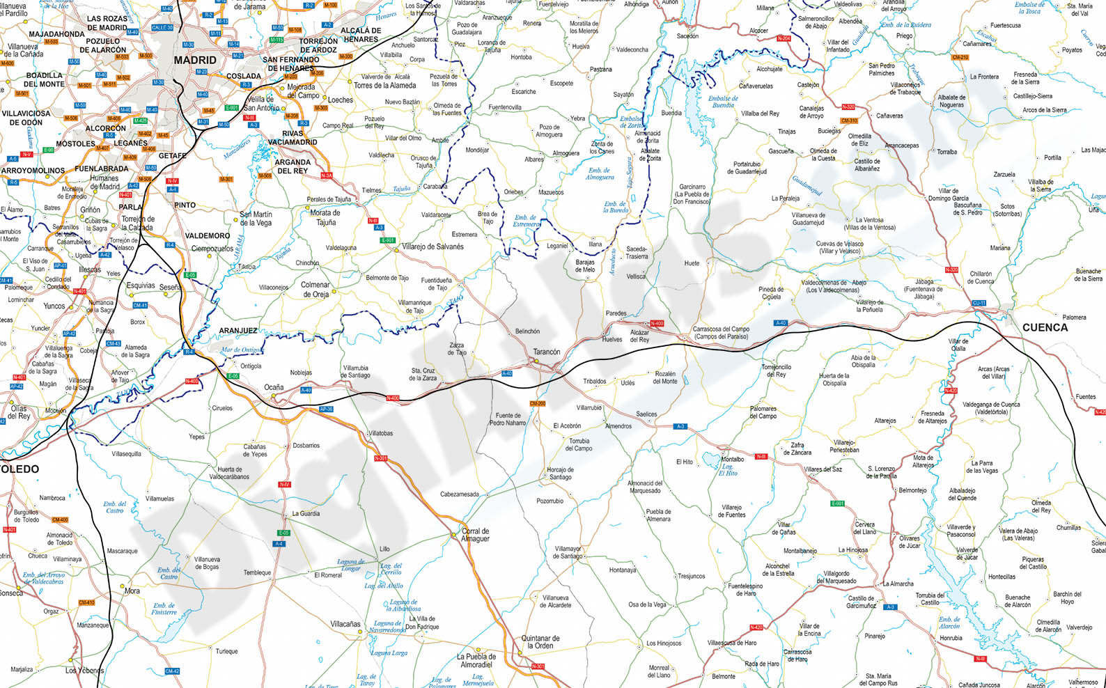
Detailed Road Map of Spain and Portugal
Detailed digital road map of Spain and Portugal, at a working scale of 1:100.000 and adjusted to poster size of 2 meters wide.
(...) Read more »
Adobe Illustrator, Acrobat PDF

Ask price
Detailed roads and cities map of Spain
Detailed vector road map of Spain (excluding Portugal) at a scale of 1:600.000 and adjusted to 2 meters wide.
(...) Read more »
Acrobat PDF

59,00 €
Major roads map of Spain and Portugal
Digital map of Spain and Portugal with the general road network, hydrographic network and main towns.
(...) Read more »
Adobe Illustrator, Acrobat PDF

79,00 €
Map of some provinces of Spain
Map of the spanish provinces of Albacete, Alicante, Cuenca and Region of Murcia.
It includes the entire road network, municipalities and population centres.
(...) Read more »
Adobe Illustrator, Acrobat PDF

98,00 €
Map of south-eastern Spain
Digital map of roads and towns in south-eastern Spain.
(...) Read more »
Adobe Illustrator, Acrobat PDF

19,95 €
Map of Spain
Political map of Spain in digital format.
(...) Read more »
Adobe Illustrator, Acrobat PDF

120,00 €
Map of Spain 100x70 cm
Poster size map of Spain and Portugal, 100x70 cm.
(...) Read more »
Adobe Illustrator, Acrobat PDF
55,00 €
Map of Spain and Portugal DIN A3
Map of Spain and Portugal with major cities and roads. DIN A3 paper size. vector file 100% editable
Illustrator, PDF

55,00 €
Map of Spain and Portugal with cities
Digital map of Spain and Portugal with regional and provincial boundaries and a large number of towns.
(...) Read more »
Adobe Illustrator, Acrobat PDF

55,00 €
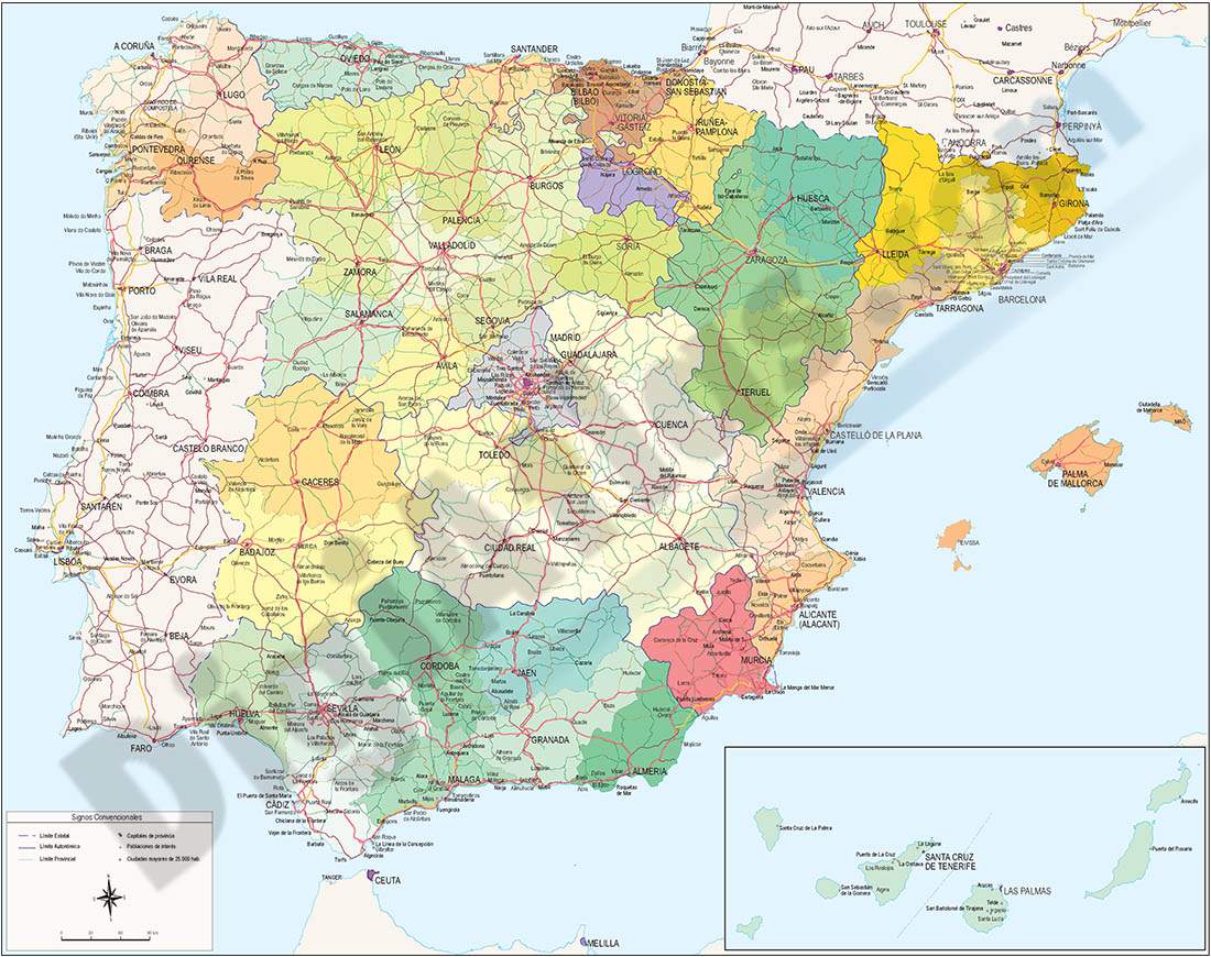
Map of Spain and Portugal with communities and provinces
Political map of Spain and Portugal in digital format, showing the internal administrative division of each country, Spanish Autonomous Communities and provinces, and the continental districts and autonomous regions (Azores and Madeira) of Portugal, all of them with their respective capitals.
Two vector files are downloaded: one in Adobe Illustrator 100% editable, to be able to select and colouring each community, region and province separately, as well as edit colors, texts and styles. Another version in Acrobat PDF ready for press at the desired size always with the highest resolution and quality. Both versions are organized in separate layers, which can be displayed and hidden in order to generate customized versions of the map.
See less «
Adobe Illustrator, Acrobat PDF.

55,00 €
Map of Spain with cities over 25,000 citizens
Digital map of Spain showing cities and towns with more than 25,000 inhabitants.
(...) Read more »
Adobe Illustrator, PDF, JPG (300dpi)

55,00 €
Map of Spain with postal codes
Map of Spain showing Autonomous Communities, provinces, major cities and 2-digit postal codes. Fully editable and resizable vector file formats.
Adobe Illustrator, Acrobat PDF

55,00 €
Map of Spain with provinces and major cities (over 10000 citizens)
Digital map of Spain with regional and provincial boundaries, municipalities and all the towns with more than 10,000 inhabitants.
(...) Read more »
ArcView Shapefile (.shp)

59,99 €
Maps of 17 Autonomous Communities of Spain
Separated vector file for all Spanish Autonomous Communities. Map files contains a lot of political information, such as roads and cities. Also includes a TIFF images relief.
Adobe Illustrator, Acrobat PDF, TIFF