
79,00 €
Catalonia - postalcode by municipality and comarca
Excel file with all zipcodes of Catalonia, their municipality, comarca and coordinates.
Excel

Ask price
Chile - map of 3 digit postal codes
Digital cartography of Chile with 3-digit postcodes.
The first three digits of the Chilean postcodes correspond to the communes.
Georeferenced file in Shapefile (.shp) format.
Shapefile (.shp)

59,00 €
Ciudad Real - map of spanish province with municipalities and postal codes
Digital map of the province of Ciudad Real (Castilla-La Mancha) with municipalities, capitals, cities and towns grouped according to their number of inhabitants and the areas of all 5-digit postcodes.
(...) Read more »
Adobe Illustrator, Acrobat PDF

Ask price
Colombia - map of 4 digit postal codes
Digital map of Colombia with the 4-digit postcodes.
Georeferenced cartography of Colombia with the 4-digit postal zones, which refer to the departments and regional zones.
(...) Read more »
Shapefile (.shp)

98,00 €
Community of Madrid - Digital map with municipalities and postal codes
Vectorized high-quality poster size map of Madrid autonomous community showing detailed urban areas, 5-digit postal code limits, municipalities and major roads. Downloads fully editable Adobe Illustra
(...) Read more »
Adobe Illustrator, PDF

59,00 €
Córdoba - province map with municipalities, postal codes and roads
Digital map of province of Córdoba (Andalusia, Spain), showing municipalities borders, 5-digit postcode areas andmajor roads. Continuously Updated and fully editable vectorized file.
Adobe Illustrator, PDF

55,00 €
Coventry - map of postcode area (CV) with cities and major roads
Vectorized and fully editable map of Coventry postcode area (CV). Map includes cities, major roads, postcode districts and postacode sectors.
Adobe Illustrator, PDF, JPG (300dpi)

55,00 €
Derby - map of postcode area (DE) with cities and major roads
Vectorized and fully editable map of Coventry postcode area (DE). Map includes cities, major roads, postcode districts and postacode sectors.
Adobe Illustrator, PDF, JPG (300dpi)

89,00 €
Euskadi - map of postal codes
EUSKADI POSTAL CODES
(...) Read more »
Adobe Illustrator, Acrobat PDF

89,00 €
Euskadi and Navarra - map of postal codes
EUSKADI POSTAL CODES
(...) Read more »
Adobe Illustrator, Acrobat PDF

75,00 €
Gijón - city map with postal codes
Digital street map of Gijón (Principality of Asturias) with urban area delineation, municipal boundaries, postcode limits, and street and square names. Poster size map 1189x841 cm (A0).
(...) Read more »
Adobe Illustrator, Acrobat PDF

59,00 €
Girona - province map with municipalities, comarcas and postal codes
Fully editable vector file of province of Girona, showing municipalities borders, coloured comarcas and 5-digit postcode areas.
Adobe Illustrator, PDF

59,00 €
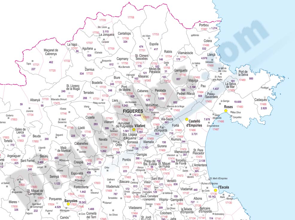
Girona - province map with municipalities, postal codes and inhabitants
Fully editable vector file of province of Girona, showing municipalities borders, 5-digit postcode areas and inhabitants.
Adobe Illustrator, Acrobat PDF

59,00 €
Girona - province map with municipalities, postal codes and roads
Fully editable vector file of province of Girona, showing municipalities borders, 5-digit postcode areas and roads.
Illustrator, PDF

59,00 €
Granada - city map with postcodes
Postal code map of Granada city, capital of province of Granada (autonomous community of Andalusia, Spain), in digital format showing urban blocks of buildings, parks and green zones, street and squar
(...) Read more »
Adobe Illustrator, PDF, JPG (300dpi)

