1- Map of Europe with 2-digit postal codes
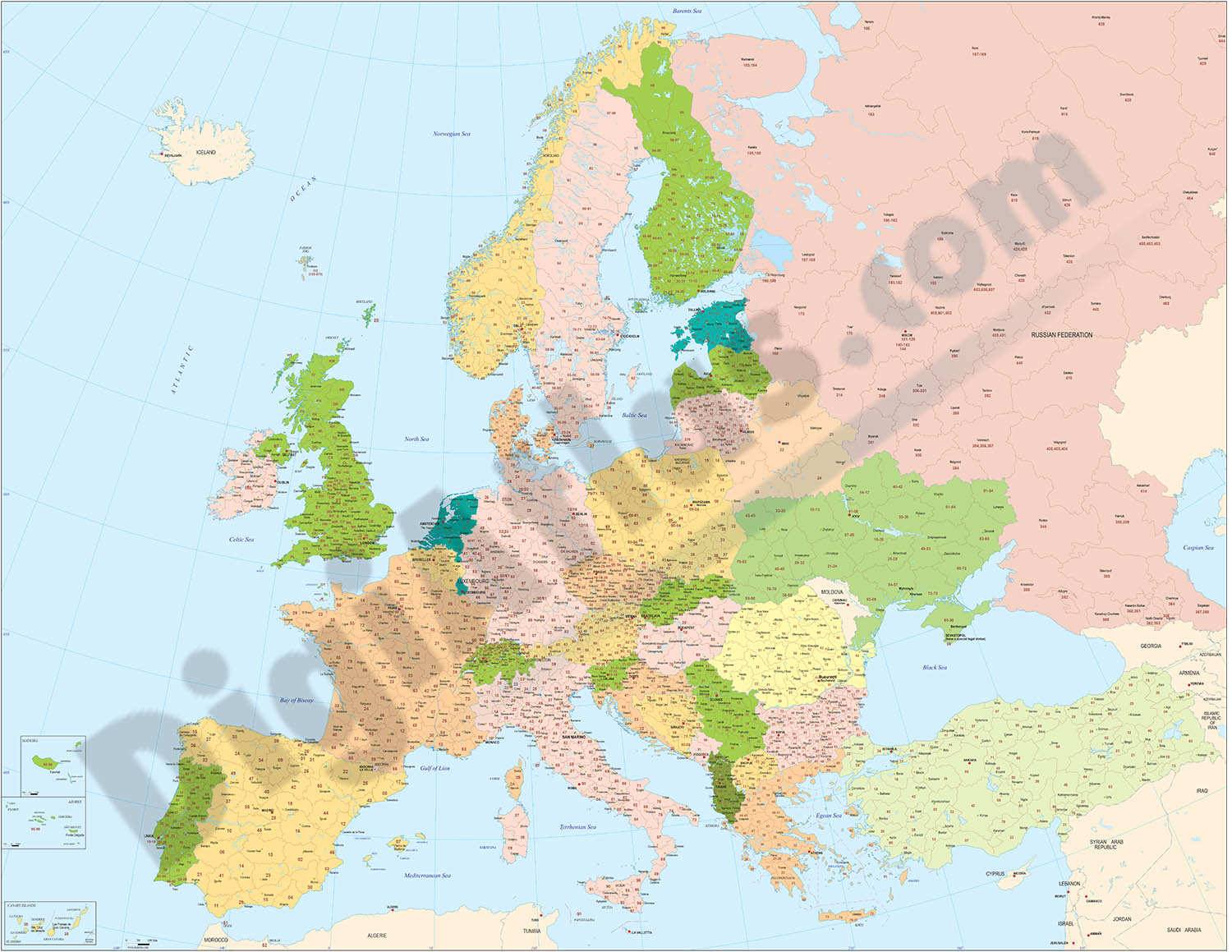
Political map of Europe, in fully editable digital format, with the countries coloured, the regions and provinces with their capitals and the two-digit postal codes.
Two files are downloaded in vector format (Adobe Illustrator and Acrobat PDF),... Read more
Adobe Illustrator, Acrobat PDF
2- Maps of Central and South american countries with political division

Digital maps of Argentina, Bolivia, Brazil, Chile, Colombia, Ecuador, Guyana, Paraguay, Peru, Surinam, Uruguay, Venezuela, Guatemala, Belize, Honduras, El Salvador, Nicaragua, Costa Rica, Panamá and Mexico, with their administrative division.... Read more
Adobe Illustrator, Acrobat PDF
3- Physical-Political Poster World map
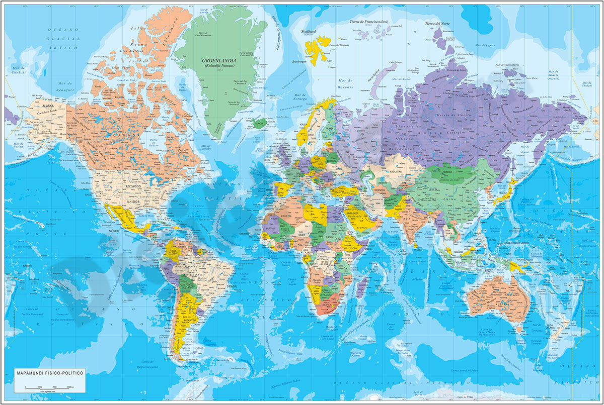
Physical and political digital world map, with borders, colours and names of countries, capitals, main rivers and lakes, capitals and important towns, geographical names and the altimetry and bathymetry strips of the land and sea relief.
Files... Read more
Adobe Illustrator, Acrobat PDF
4- 15 maps of Spanish provinces with comarcas and municipalities

Digital maps of 15 provinces of Spain with comarcas and municipalty borders and city names. (Cáceres, Badajoz, Albacete, Ciudad Real, Toledo, Alicante, Castellón, Valencia, Murcia, Burgos, León, Salamanca, Valladolid, Canarias and Baleares... Read more
imagen JPG (250 dpi)
5- A Coruña (Corunna) - Map of province with parroquias and aldeas

Map of A Coruña province (Galicia, Spain) showing Autonomous Communities, provinces, concellos and parroquias boundaries. Include cities, 'aldeas', highways, major and minor roads, railroad, principal rivers and lakes and other relevant political... Read more
Adobe Illustrator, PDF
6- Africa physical vectorized-relief map

Physical map of Africa.
Digital map of the African continent with the altimetry and bathymetry strips coloured and separated into fully editable layers. Includes geographical names, country boundaries, capitals, cities and major... Read more
Adobe Illustrator, Acrobat PDF
7- Africa political and geographical map

Fully editable vectorized file map of Africa with coloured countries, international boundaries, major lakes, important cities and capitals and relevant geographic features. Poster size map in high-resolution color shaded relief TIFF image.
Adobe Illustrator, PDF + TIFF, JPG (300dpi)
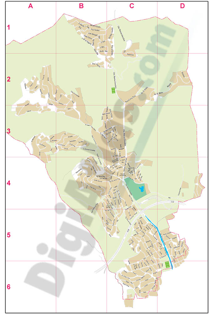
8- Aguilas (Murcia) - city map

Vector-file map of Aguilas city (Region de Murcia, Spain). Political and touristic map of Aguilas with all map features organized in separate layers.
Adobe Illustrator, PDF
9- Alava (Araba) - Map of the province

Digital map of the province of Araba/Álava (Basque Autonomous Community)
Cartography at a scale of 1:300,000 with regional and provincial boundaries, municipalities and towns, motorways, dual carriageways, national and regional roads of the... Read more
Adobe Illustrator, Acrobat PDF

11- Alella (Barcelona) - city map
Vector-file map of Alella (Catalonia, Spain) city. All features are in separated layers.
Adobe Illustrator, PDF
12- Alfàs del Pi (province of Alicante) - city map

Vector-file map of l'Alfàs del Pi (province of Alicante, Valencian Community, Spain). All features are in separated layers.
Adobe Illustrator, PDF
13- Algar de Palancia map

Map of Algar de Palancia in digital format, showing relief and urban area
Adobe Acrobat PDF
14- Algemesi - city map

Vector-file map of Algemesi city (Valencia province, Spain). All features are in separated layers.
Adobe Illustrator, PDF
15- Alicante - Map of province

Vector format spain province map showing community and province boundaries, cities, highways, major and minor roads, railroad, principal rivers and lakes and other relevant political information. Scale 1:200.000.
Adobe Illustrator, PDF, JPG (300dpi)
