
120,00 €
Roadmap of Spain and Portugal
Digital map of roads and towns in Spain and Portugal.
(...) Read more »
Adobe Illustrator, Acrobat PDF
55,00 €
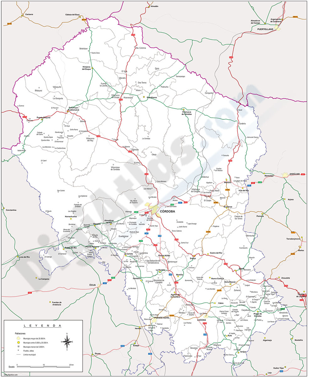
Cordoba province map with municipalities borders and major roads
Map of Cordoba (Cordova) province (Andalucia-Spain) showing municipalities borders, cities and major roads.
Adobe Illustrator, PDF

Ask price
Detailed Road Map of Spain and Portugal
Detailed digital road map of Spain and Portugal, at a working scale of 1:100.000 and adjusted to poster size of 2 meters wide.
(...) Read more »
Adobe Illustrator, Acrobat PDF

Ask price
Detailed roads and cities map of Spain
Detailed vector road map of Spain (excluding Portugal) at a scale of 1:600.000 and adjusted to 2 meters wide.
(...) Read more »
Acrobat PDF

59,00 €
Major roads map of Spain and Portugal
Digital map of Spain and Portugal with the general road network, hydrographic network and main towns.
(...) Read more »
Adobe Illustrator, Acrobat PDF

75,00 €
Map of Benelux
Digital map of Benelux (intergovernmental cooperation between Belgium, the Netherlands and Luxembourg) with motorways and major roads, major rivers and lakes and the internal administrative division o
(...) Read more »
Adobe Illustrator, Acrobat PDF

89,00 €
Map of Catalonia and Aragon with all roads and cities
Detailed map of Catalonia and Aragon autonomous communities at scale 1:300,000 showing all motorways, national, regional and local roads and all towns and villages. vectorized file organized in separa
(...) Read more »
Adobe Illustrator, PDF, JPG (300dpi)

55,00 €
Map of Itally
Road map of Italy, showing cities, major river and lakes and provincial boundaries.
All features are in separated layers.
Adobe Illustrator, Acrobat PDF

55,00 €
Map of Netherlands with major roads
Digital road map of the Netherlands
Includes layers for motorways, national roads and internal administrative divisions, including names and capitals.
(...) Read more »
Adobe Illustrator, Acrobat PDF

19,95 €
Map of Paraguay with major roads
Fully editable vector file. Include roads, political layers of inner administrative division, with their names and capitals.
Adobe Illustrator, PDF

19,95 €
Map of Poland roads and cities map
Digital political map of the Republic of Poland with regions or Voivodeships, provinces, main roads and settlements grouped according to their number of inhabitants.
(...) Read more »
Adobe Illustrator, Acrobat PDF
79,00 €
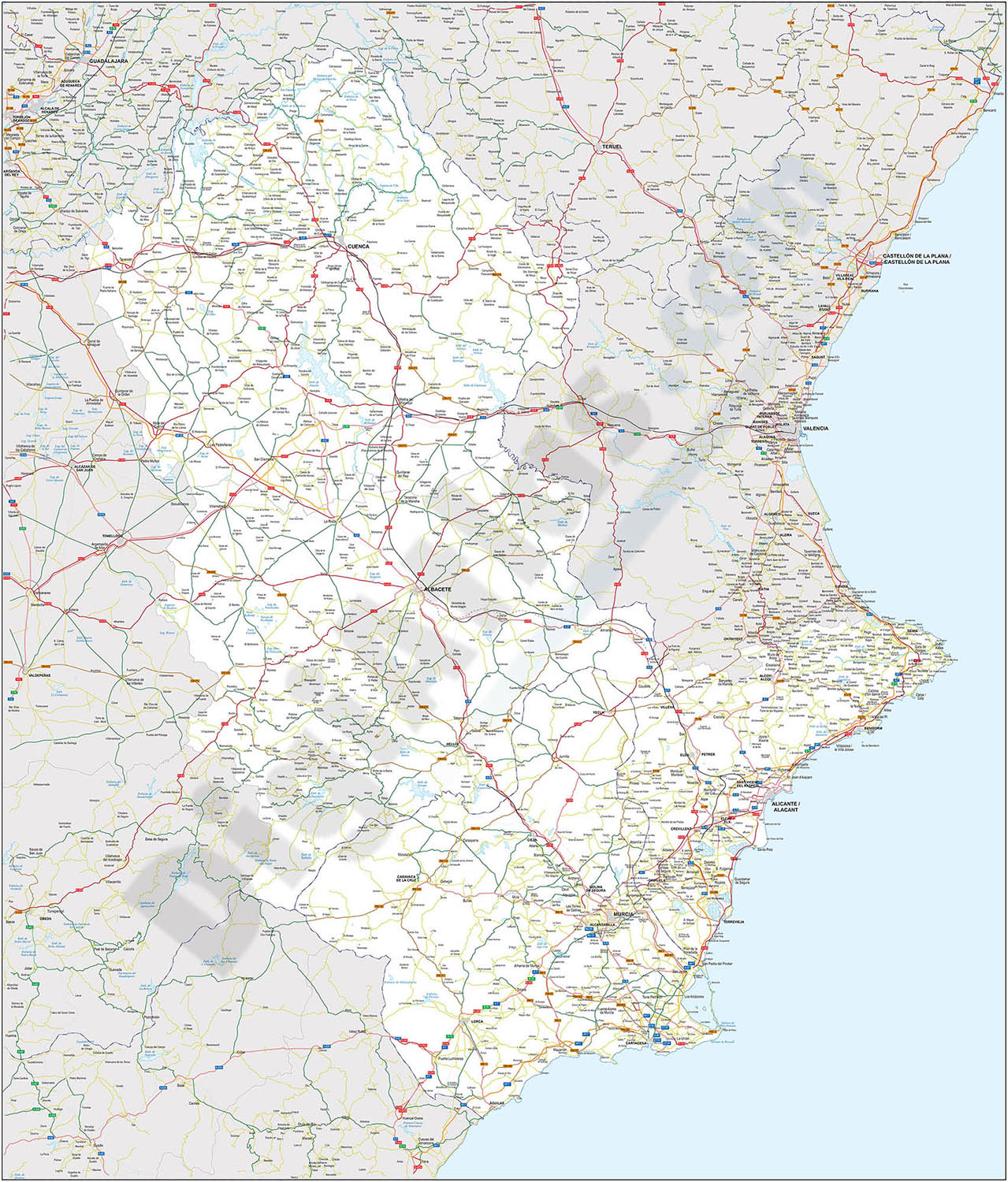
Map of some provinces of Spain
Map of the spanish provinces of Albacete, Alicante, Cuenca and Region of Murcia.
It includes the entire road network, municipalities and population centres.
(...) Read more »
Adobe Illustrator, Acrobat PDF

79,00 €
Maps of Albacete and Valencia with municipalities and roads
Digital maps of the provinces of Albacete and Valencia, in separate files.
The maps show the municipalities and roads in vector format.
Adobe Illustrator, Acrobat PDF

125,00 €
Northern roadmap of Spain
Vector file map of Cantabria, Basque Country, Navarra, La Rioja and Aragón Autonomous communities of Spain, with all cities and roads, railroad, principal rivers and lakes and other relevant politica
(...) Read more »
Adobe Illustrator, Acrobat PDF

55,00 €
Road Map of Portugal
Digital road map of Portugal, with the motorways, dual carriageways and the main road network. Also include towns and villages
(...) Read more »
Adobe Illustrator, Acrobat PDF