
350,00 €
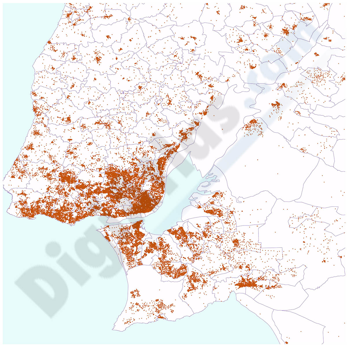
Portugal - Population by 7-digit postal code
Excel file with the inhabitants by 7-digit postcodes of Portugal.
(...) Read more »
Excel

125,00 €
Portugal - Excel population by 4-digit postal code
Excel file with the inhabitants by 4-digit postcode of Portugal.
Demographic data of Portugal. Number of inhabitants per 4-digit postcode area of all Portugal (mainland and autonomous archipelagos of Azores and Madeira).
Excel file structure:
id (unique identifier of each postcode area)
CP4 (4-digit postcode)
Distrito
Concelho
xcoord - ycoord (centroid coordinates)
Total inhabitants
Total Men
Total Females
0 to 14 years old
15 to 24 years
25 to 64 years old
over 65 years old
- Click here to download a sample.
See less «
Excel

Ask price
Argentina - map of 4 digit postal codes
Digital map of the postal codes of Argentina in georeferenced Shapefile format.
Shapefile (.shp)

Ask price
Colombia - map of 4 digit postal codes
Digital map of Colombia with the 4-digit postcodes.
Georeferenced cartography of Colombia with the 4-digit postal zones, which refer to the departments and regional zones.
(...) Read more »
Shapefile (.shp)

Ask price
Chile - map of 3 digit postal codes
Digital cartography of Chile with 3-digit postcodes.
The first three digits of the Chilean postcodes correspond to the communes.
Georeferenced file in Shapefile (.shp) format.
Shapefile (.shp)

275,00 €
Portugal - population by 4 digit postal codes
Digital map of Portugal postcodes with population data.
(...) Read more »
Shapefile, Excel
Ask price
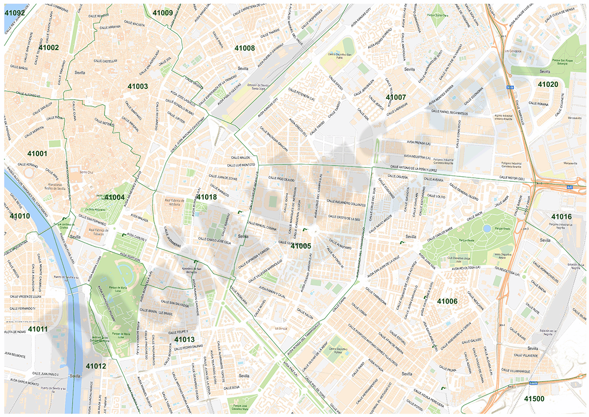
Portugal - map of 7 digit postal codes
Points with coordinates of 7 digit postal codes of Portugal.
(...) Read more »
Shapefile (.shp), Excel (.xlsx)

95,00 €
Portugal - map of 4 digit postal codes
Digital map of postcodes and towns in Portugal.
The map includes the boundaries of districts and municipalities, capitals, towns, major roads and 4-digit postcode areas.
(...) Read more »
Adobe Illustrator, Acrobat PDF
Ask price
Maps of Spain with Postal Codes areas
Postal codes map of Spain
Georeferenced cartography of all postal codes in Spain (peninsula, Balearic Islands, Canary Islands, Ceuta and Melilla).
(...) Read more »
Shapefile format (.shp), KML

59,00 €
Map of Lleida province with municipalities and postal codes
Map of Lleida province (Catalonia, Spain) showing municipalities borders and 5-digit postal codes areas. Fully editable vectorized file organized in separate layers.
Adobe Illustrator, Acrobat PDF

55,00 €
Map of Benelux with regions and Postal Codes
Digital map of Benelux (Belgium, Netherlands and Luxembourg), showing regions, capitals and 2-digit postal code areas. Vectorized and fully editable file organized in separate layers.
Adobe Illustrator, PDF, JPG (300dpi)

59,00 €
Map of Valencia with municipalities, major roads and postal codes
Map of province of Valencia (Valencian Community, Spain) showing municipal boundaries, cities and towns, 5-digit postal code areas and major roads. Fully editable vectorized file organized on separate
(...) Read more »
Adobe Illustrator, PDF