


PACK DIGIATLAS
Download up to 15 digital maps of your choice through a subscription to the 'Pack DigiAtlas'.
-Description:
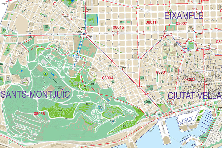
Street map of the city of Barcelona with districts and postcodes in digital format.
Map of the entire municipal area of Barcelona with the delineation of the urban area, blocks of houses and unique buildings, hydrographic network, parks, green areas, metro and railway stations, urban roads, district boundaries and all the postcodes and the names of streets and squares.
Two files are downloaded in vector format: Adobe Illustrator (.ai) 100% editable, which allows you to modify and customise colours, texts and styles, as well as to select and colour districts and postcodes separately. A second version in Acrobat PDF format allows the map to be printed directly at the desired size, always with the highest resolution. Both formats are organised in layers that can be displayed and/or hidden to generate different customised versions of the map.
The digital map of Barcelona is created and optimised for use in personal or professional graphic design projects, such as travel agencies, setting up commercial areas, distribution and sales areas, delivery routes, advertising, etc. Updated to the current year.
-Original measurements:
150x1143 cm (Fully resizable vector file for High-quality printing).
-Download formats:
Adobe Illustrator, Acrobat PDF
-You can also request a quote » to modify this map and adapt it to your projects.
Download up to 15 digital maps of your choice through a subscription to the 'Pack DigiAtlas'.

Postcode maps of cities, regions and countries. Optionally with demographic data for geo-marketing projects.

City street maps with delineation of urban areas, streets, squares, parks, green areas, buildings of interest, etc.
DigiAtlas select every week until three random maps from their catalog and intends to offer them at a very lower price than its regular cost.
These maps change every 7 days. If either of them matches your interest take advantage of this opportunity to acquire digital maps to a very special price.