
Ask price
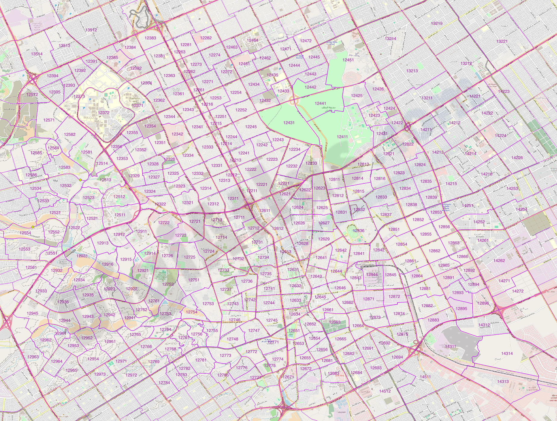
Saudi Arabia and UAE zip codes map with demographic data
Digital map of Saudi Arabia and United Arab Emirates (UAE), in geo-referenced vector Shapefile format, with 5-digit postal code areas and demographic data on population aged 0-5 years and women of rep
(...) Read more »
Shapefile format (.shp)
275,00 €
Portugal - population by 4 digit postal codes
Digital map of Portugal postcodes with population data.
(...) Read more »
Shapefile, Excel

Ask price
Portugal - map of 7 digit postal codes
Points with coordinates of 7 digit postal codes of Portugal.
(...) Read more »
Shapefile (.shp), Excel (.xlsx)

Ask price
Population for every postcode in France
- Number of inhabitants of each postal code in France .
(...) Read more »
Shapefile (.shp)

55,00 €
Binefar - city map
Digital map of Binefar city (province of Huesca, Autonomous community of Aragon, Spain) showing urban area, streets and squares delineation, blocks of buildings, parks, green areas and urban toponymy.
(...) Read more »
Acrobat PDF

55,00 €
Community of Madrid - Population by Zip Code
NUMBER OF INHABITANTS BY ZIP CODE OF THE COMMUNITY OF MADRID.
Excel file with all the zip codes of the Community of Madrid with population data. Updated to 2024.
(...) Read more »
Excel

55,00 €
Finland, Norway and Sweden - city map
Detailed map of Finland, Norway and Sweden showing the inner administrative division, counties and municipality borders and a larger number of towns and cities. Poster size map in PDF vectorized file
(...) Read more »
Acrobat PDF

75,00 €
India - city map
Detailed map of India (Republic of India) showing the inner administrative division, states and union territories, municipality borders and many names of towns and cities. Poster size map in PDF vecto
(...) Read more »
Acrobat PDF

55,00 €
Colombia - city map
Detailed map of Colombia (Republic of Colombia) showing the inner administrative division, departments, the Capital District of Bogotá, municipality borders, a lot of towns and cities. Poster size ma
(...) Read more »
Acrobat PDF

55,00 €
Brazil - city map
Detailed map of Brazil showing the inner administrative division, states, towns and cities. Poster size map in PDF vectorized file format.
Acrobat PDF

79,00 €
Maps of Albacete and Valencia with municipalities and roads
Digital maps of the provinces of Albacete and Valencia, in separate files.
The maps show the municipalities and roads in vector format.
Adobe Illustrator, Acrobat PDF

179,00 €
Barcelona and surroundings with postal codes
Digital map of the municipalities of Barcelona, l'Hospitalet de Llobregat, Santa Coloma de Gramanet, Sant Adrià del Besòs and Badalona with postal codes .
(...) Read more »
Adobe Illustrator, Acrobat PDF

48,40 €
La Cañada digital map
Digital map of La Cañada urbanization, municipality of Paterna, province of Valencia.
Map in Acrobat PDF vector format in poster size.
Acrobat PDF

102,85 €
Street map of Cornella from Badalona
Digital street map of the urban area from Cornellà de Llobregat to Badalona with colored municipalities and the urban area of Esplugues de Llobregat, l'Hospitalet de Llobregat, Barcelona, Santa Colom
(...) Read more »
Adobe Illustrator, Acrobat PDF

71,39 €
Badalona, Santa Coloma de Gramanet and Sant Adrià del Besòs with postal codes
Map of the Badalona, Santa Coloma de Gramanet and Sant Adrià del Besòs with 5-digit coloured postal code areas in vectorized PDF format. Also shows urban blocks of buildings, parks, green zones, street and square names.
See less «
Acrobat PDF

