
71,39 €
Badalona, Santa Coloma de Gramanet and Sant Adrià del Besòs with postal codes
Map of the Badalona, Santa Coloma de Gramanet and Sant Adrià del Besòs with 5-digit coloured postal code areas in vectorized PDF format. Also shows urban blocks of buildings, parks, green zones, str
(...) Read more »
Acrobat PDF

59,00 €
Barcelona - province map with municipalities, postal codes and roads
Fully editable vector file of province of Barcelona, showing municipalities borders, 5-digit postcode areas and roads.
Illustrator, PDF

179,00 €
Barcelona and surroundings with postal codes
Digital map of the municipalities of Barcelona, l'Hospitalet de Llobregat, Santa Coloma de Gramanet, Sant Adrià del Besòs and Badalona with postal codes .
(...) Read more »
Adobe Illustrator, Acrobat PDF

125,00 €
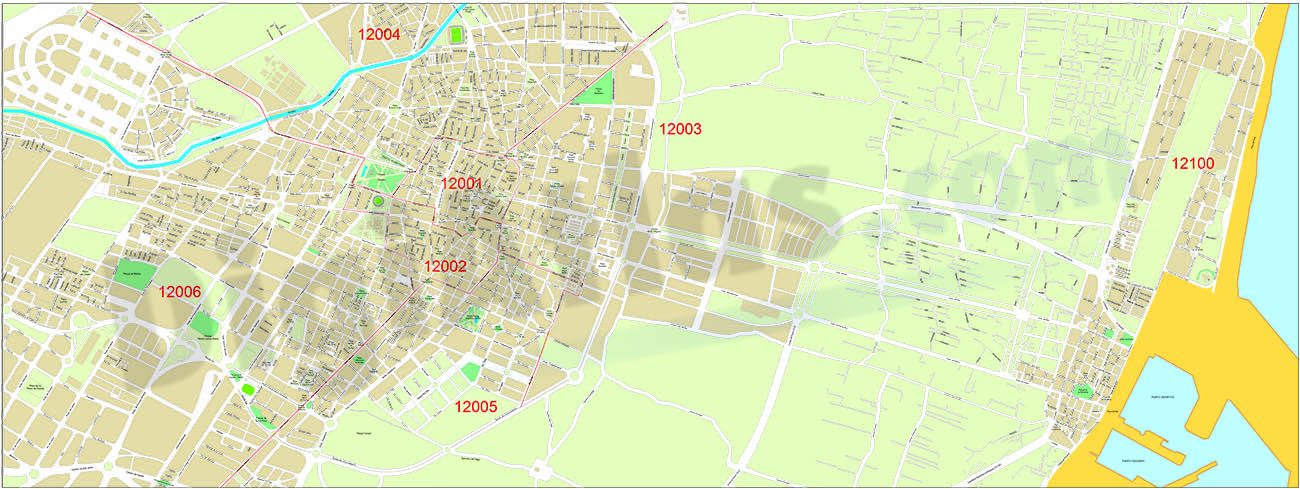
Barcelona city map with postcode districts
Street map of the city of Barcelona with districts and postcodes in digital format.
(...) Read more »
Adobe Illustrator, Acrobat PDF

95,00 €
Bilbao - city map with postal codes
Digital street map of the city of Bilbo/Bilbao (Euskadi) with the delineation of blocks of houses, singular buildings, hydrographic network, parks, green areas, railroads, urban roads, postal codes an
(...) Read more »
Adobe Illustrator, Acrobat PDF

55,00 €
Birmingham - map of postcode area (B) with cities and major roads
Vectorized and fully editable map of Birmingham postcode area (B). Map includes cities, major roads, postcode districts and postacode sectors.
Adobe Illustrator, PDF, JPG (300dpi)

55,00 €
Braga - map of postcode area (CV) with cities and major roads
Vectorized and fully editable map of district of Braga (Portugal). Map includes cities, major roads and 4-digit postcode areas.
Adobe Illustrator, PDF

95,00 €
Burgos - city map
Digital map of Burgos capital city (Province of Burgos, autonomous community of Castile and León, Spain). Maps include streets and square, their names and postal code areas. All features are in separ
(...) Read more »
Adobe Illustrator, PDF

59,00 €
Cartagena - city map
Digital street map of Cartagena (Region of Murcia, Spain).
(...) Read more »
Adobe Illustrator, Acrobat PDF
55,00 €
Castellón de la Plana - center with postal districts
Vector-file map of Castellón de la Plana - Castelló de la Plana (province of Castelló, Spain) with postal codes and districts.
Adobe Illustrator, Acrobat PDF

98,00 €
Castellón de la Plana - city map
Vector-file map of Castellón de la Plana - Castelló de la Plana (province of Castelló, Valencian autonomous community). Digital map in vector format with all cartographic features organized in sepa
(...) Read more »
Adobe Illustrator, Acrobat PDF

122,50 €
Castile-La Mancha - map of postal codes and municipalities
Vector-file map of Castile-La Mancha autonomous community (Spain) with cities, towns, municipalities borders and 5-digit postal codes. Continuously Updated
Adobe Illustrator, PDF, JPG (300dpi)

132,50 €
Castile-La Mancha - map of postal codes, municipalities and major roads
Vector-file map of Castile-La Mancha autonomous community (Spain) with cities, towns, municipalities borders and 5-digit postal codes.
Adobe Illustrator, Acrobat PDF

79,00 €
Catalonia - map of postal codes
Digital map of Catalonia (Catalonia) with postcode areas. Georeferenced vectorial cartography in Shapefile (.shp) format.
Shapefile

79,00 €
Catalonia - Map with postal codes, municipalities, comarcas and major roads
Map of postal codes, roads and comarcas of Catalonia autonomous community (Spain). Map shows all municipalities borders and capitals, colored comarcas, all 5-digit postal code areas and major roads.
Adobe Illustrator, Acrobat PDF

